


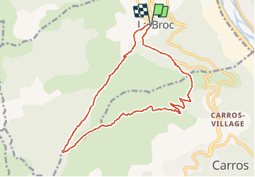
Tour de la Peloua broc

Benteux
User

Length
9.2 km

Max alt
892 m

Uphill gradient
452 m
Km-Effort
15.3 km

Min alt
445 m

Downhill gradient
459 m
Boucle
Yes
Creation date :
2020-12-09 22:10:28.464
Updated on :
2020-12-09 22:11:11.653
3h07
Difficulty : Difficult

FREE GPS app for hiking
 SityTrail
IGN / Geographical institutes
SityTrail Plus
The world is yours!
About
Trail Walking of 9.2 km to be discovered at Provence-Alpes-Côte d'Azur, Maritime Alps, Le Broc. This trail is proposed by Benteux.
Positioning
Country:
France
Region :
Provence-Alpes-Côte d'Azur
Department/Province :
Maritime Alps
Municipality :
Le Broc
Location:
Unknown
Start:(Dec)
Start:(UTM)
352693 ; 4852296 (32T) N.
Comments